Garmin BlueChart G3 Vision 473S Pärämeri map
Shipping costs starting from
3,90€

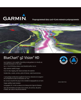
Unrivaled coverage of coastal charts
Featuring the industry's most comprehensive, clear and detailed updated coastal charts with integrated Garmin and Navionics® content
The automatic guidance1 technology calculates the route based on the desired depth and underpass height data and displays a suggested route
You can see the target depth at a glance thanks to the shading of up to 10 depth ranges
The fishing charts are detailed and facilitate navigation in marshes, canals and marinas, as they show bottom contours with an accuracy of up to 30cm (1ft)
BlueChart g3 coastal charts are the most comprehensive, clear and detailed in the industry, featuring both Garmin and Navionics content. The automatic guidance1 technology calculates the routes based on the depth and underpass height data you want and shows the recommended route to be followed on top of the map. In addition, NOAA raster maps can be downloaded free of charge with the ActiveCaptain application. In the map plotter, you can see paper map-like views of the areas mapped by NOAA, where the corresponding longitude and latitude data are marked on the individual target points. Worldwide coverage is available by region as add-on maps or as downloadable files. Each area is sold separately.
- EAN:
- SKU: 101754180
- Vendor material number: 010-C0817-00
Payment Methods: