Garmin Zumo XT motorcycle navigator
Available online only
Shipping costs starting from
4,90€

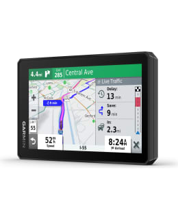
The durable zūmo® XT motorcycle navigator is designed for adventures. Its 5.5-inch ultra-bright, water-resistant screen is easy to use with gloves on. The device can withstand all types of weather conditions, extreme temperatures and vibrations. When driving on roads, you can choose winding routes turn by turn with guidance. Topographic maps and BirdsEye satellite images are at your disposal for off-road driving. Warnings for the driver help prepare e.g. tight bends and level crossings. Managing and viewing routes, tracks and waypoints is easy with the Garmin Explore™ application on your motorcycle navigator, smartphone and computer. The motorcycle navigator can be paired with a compatible inReach® satellite communication device (accessory) for sending interactive SOS messages, two-way communication and location sharing.
5.5 INCH VERY BRIGHT SCREEN
The ultra-bright 5.5-inch HD screen, suitable for use with gloves, can be mounted horizontally or vertically; the screen is designed to withstand harsh weather (IPX7) and terrain conditions.
ROAD AND TERRAIN MAPS
There is a suitable map for every driving trip, when you can choose between spoken turn-by-turn guidance on European roads, preloaded topographical maps or global BirdsEye satellite images. Map updates included.
BIRDSEYE SATELLITE IMAGES
Worldwide BirdsEye satellite images are available as direct device downloads via Wi-Fi®, with no annual fees.
EASY ROUTE MANAGEMENT
Manage and view routes, tracks, and waypoints with the Garmin Explore™ app on your zūmo XT, smartphone, or computer.
EASY TRAVEL
Preloaded with TripAdvisor® travel recommendations, iOverlander™ waypoints and Foursquare® content with millions of new and popular places.
POST SAVE
Saving and sharing the route for future trips.
WORKS WITH INREACH® SATELLITE COMMUNICATOR
By pairing the zūmo XT with a compatible Garmin inReach satellite communication device (accessory), you can access two-way communication, location information sharing and SOS messages.
DESIGN AND SHARE
Sending GPX files from your phone to your zūmo XT is easy.
GARMIN ADVENTUROUS ROUTING
The function finds winding and hilly routes that are exciting to drive.
MUSIC PLAYER
Stream and control smartphone music with the zūmo XT navigator or play MP3 files stored on the zūmo XT device.
DRIVER SAFETY FUNCTIONS
Warnings of potentially dangerous situations ahead, such as tight corners; Bluetooth® hands-free calls; Automatic registration of events, which sends your location via text message to the contact person in the event of an accident.
REAL-TIME TRAFFIC AND WEATHER INFORMATION AND MUCH MORE
Real-time traffic and weather information, route sharing with other motorists, smartphone notifications on the zūmo XT device when the smartphone is paired with a smartphone running the Garmin Drive™ app.
Technical information:
- Dimensions: L x W x D: 8.8 x 14.8 x 2.4 cm
- Screen size, WxH: 12.1 x 6.8 cm, diagonal 5.5 inches (13.9 cm)
- Screen resolution, WxH: 1280 x 720 pixels
- Weight: 262 g
- Battery: Rechargeable Lithium Ion
- Battery life: Up to 6 hours (up to 3.5 hours at 100% backlight brightness)
- Water rating: IPX7
- Warranty: 2 vuotta
- EAN: 753759256340
- SKU: 102341352
- Vendor material number: 010-02296-10
Payment Methods: